
The Northern Corridor road networks cover approximately 12,707 Km in length, distributed as follows: 567 Km in Burundi; 4,162 Km in DRC; 1,328.6 Km in Kenya; 1,039.4 Km in Rwanda; 3,543 Km in South Sudan; and 2,072 Km in Uganda.
According to data collected in the Member States;
Road transport routes
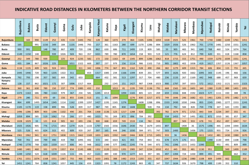
Key transit transport routes are from Mombasa to Bujumbura (the South-West terminus) covering about 2,000 km of road distance, and the Mombasa – Kisangani route which stretches for about 3,000 km. The bulk of imports and exports to and from countries in the Corridor is transported via either of these transit routes.
From Kenya to Uganda, the Mombasa – Malaba – Kampala road (1170 km) is preferred due to the relatively good quality of the network and availability of social amenities en route. The alternative route is Mombasa – Kisumu – Busia – Kampala.
The average transit time from Mombasa to Kampala in 2016 was 5 days. View the details for Average Transit Time from Mombasa to various destinations
From Uganda to Rwanda, the principal routes are Kampala – Kagitumba – Kigali and Kampala – Gatuna – Kigali; Bujumbura in Burundi is reached from Kampala through Rwanda. Bukavu, Goma, and Kisangani are also reachable from Rwanda and Uganda.
The Northern Corridor Secretariat is advocating for a much shorter route from Mombasa to Kigali and Bujumbura via the Voi-Taveta/Holili-Arusha-Siginda Road: 1,650 km to Kigali & 1,957 km to Bujumbura.